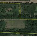
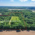
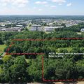
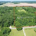
Lot outline is approximate based on county GIS data, but may not be accurate in the event that the Parcel ID or address are not correct and/or final.
Images
![Slider image thumbail number 1](https://northeasterngroup.com/wp-content/themes/northeastern/listing-images/202419618/0-0-0-c57d2257ad156777931ba4ffc3274a2c-4-a17105427aac61366ff8749c59960e94-202419618-29f78274-efff-477a-b59a-c4d73bed3438.jpg)
![Slider image thumbail number 2](https://northeasterngroup.com/wp-content/themes/northeastern/listing-images/202419618/1-0-0-e1eb737d5639f0d856037bf934ead4a6-4-a17105427aac61366ff8749c59960e94-202419618-209344e4-a748-46fd-b420-3722d3e2eddd.jpg)
![Slider image thumbail number 3](https://northeasterngroup.com/wp-content/themes/northeastern/listing-images/202419618/2-0-0-b9b4ad40dbf668d250c341d120fd5e9a-4-a17105427aac61366ff8749c59960e94-202419618-4297f355-0ec4-43cb-bceb-d2b072cb0b59.jpg)
![Slider image thumbail number 4](https://northeasterngroup.com/wp-content/themes/northeastern/listing-images/202419618/3-0-0-4f014d1d67643c9a4ab9a40a88b4b357-4-a17105427aac61366ff8749c59960e94-202419618-8e1c2d6c-af66-4651-b63c-30f03f1fdd75.jpg)
![Slider image thumbail number 5](https://northeasterngroup.com/wp-content/themes/northeastern/listing-images/202419618/4-0-0-17a22cd384b1a8f2d596f90c9c7eaf2a-4-a17105427aac61366ff8749c59960e94-202419618-3eb1be32-ded7-4a04-9389-c4652cae2bb3.jpg)
![Slider image thumbail number 6](https://northeasterngroup.com/wp-content/themes/northeastern/listing-images/202419618/5-0-0-79cba37529539b0c7a470f7f83bef66c-4-a17105427aac61366ff8749c59960e94-202419618-3ade6c8f-242e-4125-a627-8990832e8018.jpg)
![Slider image thumbail number 7](https://northeasterngroup.com/wp-content/themes/northeastern/listing-images/202419618/6-0-0-c4adb11353512c59dcd15080dd9fd1cf-4-a17105427aac61366ff8749c59960e94-202419618-495a4bd8-e487-4205-a535-504c174c7e7d.jpg)
![Slider image thumbail number 8](https://northeasterngroup.com/wp-content/themes/northeastern/listing-images/202419618/7-0-0-e34775553e875ea3f42f389e93af3aac-4-a17105427aac61366ff8749c59960e94-202419618-4e3429f3-08e0-498c-a5ae-1b0380edf0b6.jpg)
Map
Directions
From CR 6, north on CR 13 over toll rd on west side
Description
Build your dream home in the country on just over 15.21 acres. No covenants or restrictions on this vacant land that has so much potential. Over 316″ of road frontage & back part lot has over 665″ of frontage. New survey is in the process. Call today to see this property. More aerial photos will be loaded.
Details
Property Details
-
MLS #:202419618
-
Price$349,900
-
Approx. Lot Size Acres15.21
-
Approx. Lot Size SqFt662,548
-
ClassLots And Land
-
DOM28
-
Lot Dimensions15.21 acres
-
Parcel ID#
-
Property Sub-TypeAgricultural Land
-
StateIN
-
SubdivisionNone
-
Zip46514
Other Features
-
Waterfront Y/NNo
Last updated: July 27 2024, 12:01 AM
Listing courtesy of: Maria Pendley, Susie Tucker Realty
IDX information provided by the Indiana Regional MLS. IDX information is provided exclusively for consumers’ personal, non-commercial use and may not be used for any purpose other than to identify prospective properties consumers may be interested in purchasing. Data is deemed reliable but is not guaranteed accurate by the MLS. Listings displayed on this website may be subject to prior sale or removal from sale; availability of any listing should always be independently verified.
Calculator
Number of Payments
Monthly Payments
$